Have you heard about Wakatobi?
Wakatobi is a place with uniqueness and beautiful natural beauty seen from all sides. Wakatobi is an acronym for the names of four islands in southeast Sulawesi namely, Wangi-Wangi Island, Kaledupa, Tomia, and Binongko.
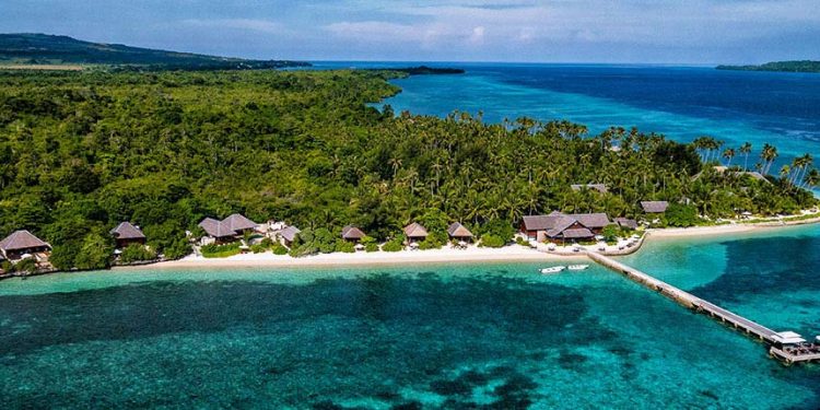
Wakatobi is a paradise for travelers from around the world. From the top, we will be treated to the beautiful natural scenery and coastal beaches. While under the sea, we will be even more impressed with the diversity of marine life.
Wakatobi belongs to the world’s coral triangle pathway, there are 6 countries included in this “golden triangle”, stretching from the South from Thailand, Malaysia, the Philippines, Indonesia (Wakatobi, Bali, Kalimantan, Lombok, and Papua), Timor Leste, Papua New Guinea and ending in the Solomon Islands in the Pacific Ocean. And we can be proud, Indonesia with Wakatobi in it, right in the heart of the world’s golden triangle of coral.
Based on data reported from Operational Wallacea, Wakatobi has more than 750 species of coral (coral) from 850 species of coral in the world, more and more diverse than the diversity of corals owned by the Caribbean. So, it is not wrong if we say that the beauty of the underwater world of Wakatobi is worth the wealth on its surface and land. Added with the cultural variety on each island that has a variety of cultures.
Wangi-wangi Island
Wangi-wangi Island is the capital of the Wakatobi Regency and at the same time a district in Southeast Sulawesi, Indonesia. Wangi-wangi Island or also called Wanci has an area of approximately 23,359 km. Among the small islands, only Kapota is inhabited by residents. Wangi-wangi Island is also surrounded by atolls that seem to be entangled, according to the people here, this atoll is said to protect the fragrance in the event of an underwater tectonic earthquake and tsunami.
There is a comfortable place to stay, Patuno Resort name, this inn is located not far from Matahora Airport, approximately 2 Kilometers. This resort offers a stunning stretch of beach views, a traditional architectural style typical of coastal areas based on wood. There are various spots that must be visited in Wangi-scented include, Cemara Beach, Molii Sahatu Beach, Wungka Toliamba, underwater Goa in Kontamale, Teekosapi and Topa Mandati. Wangi-wangi Island is also inhabited by many Bajo tribes, who have a lot of activities in the sea and are very dependent on the ocean.
Kaledupa
The island is located in the south of Wangi-wangi island in the north of Tomia island and in the west of Hoga island. Kaledupa consists of two parts namely, Kaledupa covering an area of 45.50 Km2 and South Kaledupa 58.50 Km2. With a population of 17,113 inhabitants. There are several tourist sites that are highly recommended to be visited including, Hoga Island, a small island with a fascinating diversity of marine life, about 15 minutes sea journey from Ambeua Village. Visitors can do snorkeling, diving, or just sunbathing. Then there are also Mangrove Forests located in Laulua Village, Langge Village, Sombano Village and other villages. Mangrove habitat itself is considered very important for the marine ecosystem around Kaledupa. In addition, there is also a natural cave in the village of Darawa that amazes anyone who visits it, Ollo Fortress and the Great Mosque of Bente with the charm of historical tourism.
Tomia
Tomia is located south of Kaledupa and east of Hoga, Tomia also consists of two parts, namely Tomia and East Tomia with a total area of 115.00 Km2, with a population of around 15,789 inhabitants.
Tourist spots worth visiting include Marimabuk, a dive site located in Waha Tomia Village.
Then there is Goa underwater Tee Lahamba in Patua Village and Hendaopa in Lagole Village. The underwater cave is also used as a source of clean water by residents. Historical tourism, there is Patua Fort with its gallant architecture.
Tomia with its Hondue Beach also offers exotic white sand. Even Lakota Beach that serves snacks / culinary specialties really spoils the tongue of tourists. Tomia Beach also offers the beauty of the highlands, commonly called the Peak of Tomia with the amazing stretch of thatch, and as far as the eye can see is a blue sea that is so beautiful with its sunset.
Binongko
Binongko is located in the southernmost part of the Wakatobi archipelago, with a total area of 156.00 Km2.
Binongko is formed from clusters of corals and as far as the eye can see we will be treated to a unique coral scene, there are also a number of hidden beaches namely Palahidu, Yoro, Buku, Melangka and We’e. Mangrove forests are widely distributed in the villages of Popalia, Taipabu and Makoro.
There is also the Palahidu Fortress, a colonial-era fort, and from here visitors can see the entire Wakatobi Islands. The most interesting thing in Binongko is, Taman Batu, a field formed from black coral over the sea located in the village of Walloindi.
How to come to Wakatobi?
Traveling from Jakarta – Wakatobi is quite time-consuming and a bit tiring because there are no direct flights there.
Travel via air from Jakarta, must be passed by transit first at Haluoleo Airport in Kendari, then connecting to Matahora Airport for approximately 45 minutes.
In addition, ticket prices are relatively expensive and only one flight schedule per day is also an obstacle because it is less profitable for tourists because we have to arrive at Wakatobi in the evening before dusk so that our time is wasted one day on the way.
But, the exhaustion that exists will be paid off by the enchanting beauty of the Wakatobi panorama that welcomes us directly when we step off the plane.


