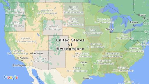
There are several websites where you can get credible and official information about COVID-19 outbreak trends in various places in the U.S. But it would also be a bit more convenient if you could have a sort of overview of the situation on an app that you use often already. Google Maps is reportedly working on a layer that would show you the number of outbreaks in a particular U.S. state or country and whether cases are going up or down in a particular region.
Renowned tipster Jane Manchun Wong tweeted about this new feature which she discovered (which she’s not sure if it’s actually new). She posted the new layers showing how the COVID-19 data layer would look like on the map. Basically each state would show a number as well as whether it’s increasing or decreasing. It also looks the same for the data outside of the U.S, but it just shows data per country and not within various places in the country.
According to XDA Developers, when this eventually goes live, users will be able to access the information like they would with the traffic, transit, and Street View information. The screenshot don’t show if you can go more granular in your data, like if you will be able to view it per city or per county. The data seem to be coming from Wikipedia, The New York Times, Johns Hopkins University, and Brihanmumbai Municipal Corporation.
Google Maps has been bringing pandemic-related new features to the app the past few months. This includes displaying reminders to wear masks, showing hotels that can be used by first responders, among other things. This possible new feature will be helpful as you plan trips both business and personal and even just for you to be aware of the number of cases near and around you.
The new COVID-19 feature doesn’t seem to be live yet in the latest version of Google Maps. Hopefully we’ll soon get an official rollout of the feature.


